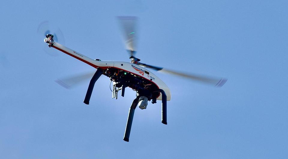
Network Rail will introduce new drones that can fly beyond the line of sight of an operator, revolutionising the way the railway is managed.
In this article:
Network Rail will introduce new drones that can fly beyond the line of sight of an operator, revolutionising the way the railway is managed.
In this article:
- Approval for drones to fly beyond visual line of sight (BVLOS) lets Network Rail rapidly respond to incidents like trespass
- BVLOS drones can reduce delays, improve safety, lower costs versus helicopters, and enable faster rail infrastructure inspections
- Trials are ongoing; integration, union support, and policy updates are needed to make this transformative technology business as usual
The use of drones flying out of sight of the pilot to work on the railway was approved by the Civil Aviation Authority in June. It’s a first for the UK, and Network Rail calls it “a game-changing development”.
Following months of trials, the CAA now permits operator Drone Major to fly, as the jargon has it, beyond visual line of sight (BVLOS).
Why does that matter to passengers?
Because it has the potential to transform the response to train delays, especially those due to trespass.
In the past year there have been 18,500 reported instances of trespass on the railway. That’s close to one incident for each of the network’s 20,000 miles of track. The incidents caused 1.5 million minutes of delay.
But 49% of trespassers have left by the time railway staff reach the site. In many cases, trains are stopped until staff have arrived to declare the area safe.
A drone could arrive more quickly, using a thermal camera to track people, collecting video evidence that could be used to prosecute offenders, and potentially enabling lines to reopen more rapidly.
“Getting trains moving quicker would be the T-shirt slogan,” says Programme Manager for National Drone Strategy Dominic Mottram.
“Normally the train driver, or whoever else spots someone on the wrong side of the fence, contacts the control room. Then a mobile operations officer is dispatched. Or incident officers. That might mean stopping all trains while information is gathered.
“A drone gets eyes on quicker, live streaming to the signalling centre or to the officer’s mobile phone. We could identify if people are there or not and make a quicker decision to reopen the railway.
“If we can also give colleagues on the ground better information in real time, they can make better decisions. They might avoid boots on the ballast, which also improves safety.”
Today, this is being done in trials with two separate drone companies.
Previously, the drones could be flown no further than the operator on the ground can see - around half a kilometre. Now they can go much further.
“This marks a landmark moment for the drone industry, positioning the UK as a world leader and opening new opportunities, especially in densely-built environments where traditional methods often fall short,” says Drone Major founder Robert Garbett.
Drone Major has been testing in Wolverhampton and on the Severn Valley Railway, where beacons on the ground keep tabs on the drone above.
Rival company Dronecloud is conducting a trial close to the regional operations centre at Saltley in Birmingham, and also at the Global Centre of Rail Excellence test facility in Wales.
Network Rail already operates around 200 drones, making it one of Europe’s largest fleets. But all have to be flown in visual contact.
Until the Civil Aviation Authority grants permission (anticipated within a few weeks), the drones cannot be flown further than the operator on the ground can see - around half a kilometre.
The infrastructure owner thinks the latest technology could fill a gap between its existing drones and its helicopter.
“We will want that to become business as usual,” says Mottram.
“But now we are working out what is best for the railway - which equipment we should use in what circumstances.
“That depends on a number of variables. The CAA permission was one. The view of trade unions is another. Network Rail standards would need to be revised, and we would need integration with our train operator colleagues. A lot of the drone work is very embryonic.”
The eye in the sky is not welcomed by everyone. Mottram says some train operators believe drones cannot be flown over their stations. This is not correct, he says - they have permission to fly over streets, houses and gardens, too.
“Dronecloud and Drone Major are the two suppliers that can do what we need. Everyone in the drone industry thinks their own product is the best thing since sliced bread. I put them in the UK’s second city to find out,” he says.
“We didn’t want to test them in rural Warwickshire or in the Cairngorms to prove they work in the middle of nowhere. There would have been a risk that the CAA would ask for it all to be done again in an intense urban environment. So, we went straight to the centre of Birmingham.
“Eighty per cent of all trespass that happen on the Chiltern route, all the way down to Marylebone, happen within five miles of the control centre in Birmingham, so it was the ideal test. In due course we propose to grow the operating area, so the whole of the West Midlands would be covered for trespass response.”
Network Rail reckons the drones could arrive on a scene within two minutes of a reported incident. It says current minimum response times are ten minutes for police and 20 minutes for Network Rail’s own staff.
Dronecloud is a business with ten staff. “We are a few weeks from permission-to-go,” explains co-founder Jan Domaradzki.
“We are in the CAA’s test and evaluation programme, and we are working with Network Rail to finesse new policies.
“We’ve agreed to fly at 75-80 feet above the head of the rail, or 50 feet above the nearest relevant ground obstacle - an overhead line, a tree, building or bridge.
“Initially we are talking about five multi-use aircraft at a hub, with two types of use: Reactive - incident management and trespass; and Proactive - asset maintenance and inspection, vegetation ingress, and tree health monitoring.”
The trial drones are fitted with thermal imaging. But lidar and daylight cameras can follow. They could be flown from a local ‘box’ with charging infrastructure over a short distance for rapid response, or flown longer distances for specific inspection work.
“Initially we are on a range of 10km [6.2 miles],” says Domaradzki.
“There’s always a lag between what the hardware and software can do, versus what the regulatory environment allows. There are already drones that can do 200km [124 miles] and fly for six to eight hours, carrying multiple payloads.”
Drone Major uses a different system, called ‘digital tethering’.
“It’s a concept I created to solve the problem of operating in space where manned aviation has no business being, like the airspace up to 50 metres over a railway line,” explains chief executive Robert Garbett.
“We use two GPS systems, that give us location accuracy down to about the size of a 50 pence coin.
“But the Civil Aviation Authority is very worried about ‘flyaway’ - if someone has bought a GPS jammer on eBay because they don’t want drones near their house, it can cause drones to get completely lost and shoot off in a random direction until they run out of battery.
“We can hop around avoiding most jammers by using different satellites. But below the GPS we have two cameras operating in the way your eyes do, calculating the location. Below that we have radar and beacons set along the railway line in positions where safety is more critical - for example, around a bridge. That gives a pinpoint truth point.
“We’ve built a safety system that is essentially like having a pilot inside the drone, monitoring all the systems intelligently and keeping the aircraft in the corridor.
“And this can work on any drone, any aircraft, on any linear infrastructure or within a defined area, such as a power station or military base. It could even work along the River Thames.”
After initial development on the Severn Valley Railway, the testing has been carried out between Wolverhampton and Dudley.
Mottram won’t reveal the cost of the project. But he points out that using a helicopter is ten times more expensive for each hour in the air. And Network Rail’s Airbus Twin Squirrel helicopter is said to cost in the region of £3,000 an hour.
But could the drone perform all the tasks of Network Rail’s existing helicopter?
“In theory, yes. It’s still early days. It can have a thermal camera, like the helicopter. If you are route-proving after a storm, looking for fallen trees or overhead wire faults, that is a useful capability for the future.
“Anything from points failing to overhead wires or third rail. Anything with a heat signature can be captured on a thermal camera in the same way it can with a helicopter. Again, that would require trade union approval and a change in Network Rail policy.”
So, where will drone technology be in three or five years’ time?
“It’s all about avoiding putting your colleagues in harm’s way. There is a perception that it could lead to people losing their jobs - I have zero intention of that.
“I can’t fix a points failure with a drone. I can’t chop down a tree with a drone. But what I can do is provide information for the people who will do that.
“If we can find faults more quickly and more safely, that is good. It means we can open the railway more quickly following severe weather or after an incident. We can improve trespass management. And it means we do not have to put boots on the ballast as often.”
Mottram acknowledges that he is not the only person bringing new drone ideas to the railway. He says British Transport Police is looking at BVLOS drones. So too is West Midlands Police.
“Right now, we could imagine a trespasser on the railway in the West Midlands, and there could be six drones in the sky - three in line of sight, three beyond line of sight, two each for Network Rail, BTP and West Midlands Police. And throughout, you have Birmingham Airport nearby.
“That is a developing conversation. Everyone sees the value in it. They all want a piece of the action. Now we have to work out how it all fits together to help trains run more efficiently.”
Dronecloud’s Domaradzki notes: “We see our target market as all critical national infrastructure. We provide the software platform that Network Rail uses to provide its entire drone operation today. We have National Highways on the platform. And Associated British Ports, and Northern Powergrid. We want to identify how organisations that share a common platform can build a joint capability.”
Drone Major’s Garbett has similar ambition. He has nine full-time staff and a handful of consultants.
“We are very optimistic. Network Rail has certainly been the trendsetter. It has been the champion of this, because it spotted the merit. Now that has been done, other critical national infrastructure organisations are approaching us for demonstrations, both here in the UK and in Europe. We are very excited.”
Medicine-carrying drones operated between the South Coast and the Isle of Wight during the pandemic, although a more recent trial across the Solent to Cowes was halted last year following local opposition.
A new £375,000 Department for Transport-funded contract to Skylift UAV permits a trial of beyond visual line of sight medical flights to the island from April to November this year.
Reading company Altitude Angel has been building a “drone corridor” called Project Skyway between Berkshire, Oxford, Coventry and Rugby.
In California, Amazon has been experimenting with drones which deliver parcels to people’s homes, and it hopes to bring the idea to the UK.
“We are testing two systems,” says Mottram.
“Drone Major uses digital tethering with beacons, Dronecloud does not. We don’t know yet which is best. Network Rail is in the vanguard of drone technology.
“We are looking at being able to fly tens of miles from base, which is going to make a huge difference. It is the equivalent of having bobbies on the beat.”
Login to continue reading
Or register with RAIL to keep up-to-date with the latest news, insight and opinion.







Login to comment
Comments
No comments have been made yet.