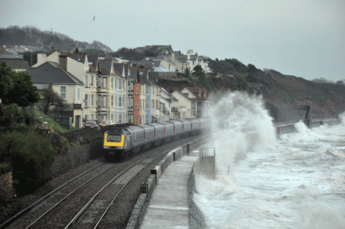
As 2015 drew to a close, CrossCountry services between Exeter and Plymouth were suspended. Worse still, 250 metres of the sea wall between Dover Priory and Folkestone Central needed to be repaired before any trains could run there. It has been a winter of storms and high seas, with little sign of the situation easing.
After the two-month closure of the railway between Exeter and Newton Abbot in 2014 due to storm and wave damage, and that of the Cambrian Coast Line for even longer that year, Britain’s coastal railways are under greater pressure than ever from the elements.
This makes a new academic study on The impact of sea level rises on transport infrastructure, published in the Journal of Transport Geography and focusing on the coastal railway between Exeter and Newton Abbot, a genuinely important document. Its authors - David Dawson, of the University of Leeds’ School of Civil Engineering; Jon Shaw, of Plymouth University’s School of Geography, Earth and Environmental Sciences; and W. Roland Gehrels, of the University of York’s Environment Department - provide an evidence-based forecast of increased disruption on this stretch of railway, with obvious implications for similar coastal routes.
Across the world the focus has long been on reducing the environmental impact of transport networks, with tougher emissions standards for internal combustion engines among the most obvious measures. Now, however, attention is starting to turn to assessing how climate change might affect transport systems, how the effects of climate change on them can be mitigated, and how they can operate effectively in the future.
One of the big impacts of climate change seems likely to be a rise in sea levels. This is why the authors chose to study the railway between Exeter and Newton Abbot, where the two-month closure in 2014 effectively cut off West Devon, Torbay and Cornwall from the national rail network.
Almost as soon as the damage to the railway became clear, estimates were made of the wider economic damage being caused to the South West by the loss of the railway. Estimates ranged from £5 million per day to as high as £20m. As the authors of this study point out: “In reality a precise figure is not known, but the impression given of a region ‘cut off’ from the rest of the country was all too keenly felt.”
The aim of the study is to assess the impact of forecast sea level rises on the functioning of the railway. It does not seek to recommend longer-term solutions such as strengthening the existing defences, re-opening closed routes or building new ones.
The railway at Dawlish has long been vulnerable. On October 5 1846, just months after it opened, the Sea Wall section was breached. And while this remains a rare occurrence in the context of the length of time the railway has been open, it is a fact that it has happened and could do again.
The authors conclude from historical research that a major line closure or blockage happens every ten years or so, but add that even smaller events can cause problems (see table, page 60). The effect of waves crashing onto the roofs of Class 220/221 diesel multiple units was documented in RAIL more than a decade ago, and since then the trains have been banned from the coastal section during periods of bad weather to prevent damage caused by saltwater ingress.
One of the potential problems to a long-term solution is highlighted early in the study. Network Rail is responsible for the 6.8km (4.2 miles) of frontage from Teignmouth to Langstone Rock, but defences immediately to the southwest are managed by Teignbridge District Council and those to the northeast by the Environment Agency.
“Despite the obvious threat from sea-level rise, a climate scoping study produced on behalf of the (now defunct) South West Regional Development Agency stated that much of the transport sector in South West England had not yet adequately responded to climate change,” write the authors. They add: “One of the enduring characteristics of multi-agency governance has been the apparent inability of key regional stakeholders to coalesce around a coherent approach to this problem.”
The storms in 2014 were a contributing factor to the damage caused along the Dawlish section, but the authors’ assumption is that sea level rises are the underlying ‘driver of change’.
In the long term, they argue, sea level change acts as a baseline for extreme sea
levels that are ultimately responsible for damaging the railway.
They examined the records of tide gauge stations at Brest and Newlyn from 1861, and compared these records with the number of overtopping-related line disruptions. The authors were then able to compare the number of Days with known Line Restrictions (DLRs) with sea level in any given year.
Since the railway opened there has been a 20cm rise in the level of the English Channel, almost half of which has occurred in the past 40 years. By plotting the 20-year moving annual average of DLRs against the average sea level height, the authors found there were two distinct periods.
The first, between 1860 and 1975, shows a “fluctuating relationship” with no clear trends, which (the authors say) suggests that sea level change had “little or no effect on the number of incidents”.
Post-1975, however, shows what the authors describe as a “clear inflection” - a tipping point. “For sea levels higher than 7,050mm above the chart datum the linear trend between average DLRs and mean sea level is significantly positive,” they say.
There is a further factor. As sea levels rise the freeboard (the height of the crest of sea defences above the water level) reduces: “…the height of the water level today is closer to the crest of the defences than has ever been recorded: 150 years of sea level rise has significantly reduced the available freeboard along the sea wall, allowing for more frequent overtopping events.”
The authors conclude that between 1975 and 2009 a 0.05m rise in water level occurred, while the average number of DLRs per year quadrupled from 0.7 to 2.9.
Network Rail’s TRUST data adds detail to this picture - it suggests that speed restrictions are imposed at Dawlish an average of five times per year and that closures of the Down (westbound) line take place four times. Complete closures have, between 1997 and 2009, averaged once every three to four years.
All of this analysis allows the authors to produce a range of predictions based on future sea level rises, to assess their potential impact on the railway. They make alarming reading. A rise in sea levels of 0.05m-0.07m by 2020 could lead to the number of DLRs doubling to 16-19 per year; by 2060 a sea level rise of 0.27m-0.39m could lead to DLRs increasing to between 46 and 63; and by 2100 a rise of 0.55m-0.81m could lead to between 84 and 120 DLRs each year.
In detail, by 2020 - just four years away - the authors suggest that speed restrictions will be imposed ten times per year, that Down line closures will happen 8.4 times per year, and complete closures every two years.
By 2060 those figures increase further, with complete closures of the route predicted twice per year and in 2100 3.6 times per year. By the turn of the century, the number of average DLRs could increase by 1,170%.
So, by 2040, if the medium-range predictions are correct, there could be some sort of service restriction on the railway at Dawlish on up to 10% of days. In the worst-case scenario envisaged, given that the worst weather happens in winter, a third of days in that time could be hit by restrictions.
The impact of Network Rail’s sea defence plans inevitably cannot be forecast. However, the authors suggest that while lengthy closures (such as that in 2014) could reduce, by the end of the century “multiple breaches, undermining and subsidence of the track with extensive damage to footpaths and offshore breakwaters can probably be expected”.
The conclusion is damning: “By 2060, with high-impact events occurring on average twice a year, the extent to which the railway would
be able to maintain a credible service has to be brought into question. Indeed, even by 2040 there are likely to be serious issues in relation to its reliability.”
The authors add: “An increase in the number of overtopping events and associated service restrictions very much beyond current norms can be expected in future decades.”
The coastal railway through Dawlish is already among the most expensive to maintain in the country for Network Rail, costing around £800,000 per year for the short section between Dawlish and Teignmouth. Then there’s an average £5m every three or four years, to deal with one-off events such as landslips.
The authors admit that it is a “rather rudimentary approach”, but by multiplying the reported average annual cost of maintenance by the estimated increase in days with DLRs they estimate that at today’s prices maintenance will cost between £5.8m and £7.6m per year by 2040.
Furthermore, these costs take no account of the compensation paid by Network Rail to train operators when the railway is disrupted or closed. The authors estimate average annual compensation paid to train operators between 1997 and 2009 to have been £270,000 per year. Should the number of DLRs increase to the high sea level rise scenario, this could increase to £1.1m per year at current prices in 2040.
The costs don’t end there. Network Rail estimates the repair costs of the February 2014 storms to have been £50m, and that works to protect and improve the current alignment could cost between £398m and £659m over 20 years. “Running trains in Devon will cost the railway industry (and ultimately the Government) even in a ‘do nothing’ scenario rather more in the future than it has in the past.”
The wider costs to the region of the two-month closure in 2014 are rather harder to quantify, and the authors suggest that the economic effects of transport disruption such as this “are not well understood and will not necessarily be captured especially successfully by variations of conventional appraisal processes”.
An alternative approach to deciding between infrastructure schemes is that rather than deciding between doing nothing, protecting the existing route or re-opening/building, an alternative might be to determine which interventions are most likely to achieve the stated aims of transport policy.
Applied to Dawlish, the authors suggest that the question might shift from “How much does it cost when the line is closed” to “How can we best ensure that as far as possible this does not happen again.” They point out that in Italy, two billion euros worth of engineering works have been completed along the Adriatic coast to reduce the vulnerability of passenger and freight travel to sea level rises and coastal storms.
In a sense, Network Rail may be somewhat in the role of King Canute in trying to hold back the tide (although that king did so to prove to his courtiers that in fact he could not). If the authors are correct, even if Network Rail significantly strengthens the Sea Wall, “it is reasonable to expect ongoing disruption because of continuing periodic overtopping of the sea defences. Whatever the policy response, there looks set to be a significant cost increase, possibly running into the billions of pounds, associated with running trains through Devon in the future.”
The ramifications of this study are clear: there is real merit in conducting similar investigations on other vulnerable stretches of railway line both in the UK and abroad.
This remarkable work, based largely on evidence and existing trends, shows that a co-ordinated and coherent approach to addressing the vulnerabilities of coastal transport infrastructure is likely to be required. Given that the impact of sea level rises on the railway at Dawlish (and by extension other locations around the country) could be noticeably worse by the end of the decade, there is no time to lose.
The full study is available at http://www.sciencedirect.com/science/article/pii/S0966692315002197
- This feature was published in RAIL 792 on January 20 2016










Login to comment
Comments
No comments have been made yet.