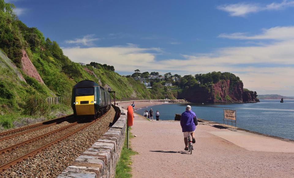
Network Rail has rebuilt the Dawlish Sea Wall and constructed a massive rockfall shelter south of the Devon resort. It was also planning to divert the railway along the Teignmouth Sea Wall, but that now won’t happen, so what’s planned instead? Nick Brodrick reports.
Extremes of weather - past, present and future - call for difficult choices to be made for Britain’s ‘Victorian’ railway.
That is certainly true for the stunning, yet problematic, four-mile section of the Exeter to Plymouth main line that skirts the English Channel - as we have already seen in the first two parts of this series examining the South West Rail Resilience Programme (RAIL 1008 and 1010).
So far, some £165 million has been spent on rebuilding the sea wall at Dawlish, building a rockfall shelter at Parsons Tunnel, and fixing extensive nails-and-netting to the cliffs above it (known as phases 1-4).
The major Network Rail infrastructure projects stemmed from the disastrous winter and spring of early 2014, when a huge chunk of Brunel’s man-made sea defence was punctured by storm-intensified waves, and when masses of rain-saturated sandstone fell from the cliffs above.
It was that collapse of 25,000 tonnes of cliff face between Holcombe and Teignmouth (close to the southern portal of Parsons Tunnel) that triggered a serious proposal to make phase 5 even more radical than the other (re)construction projects.
Attention has therefore fully turned to the final, southern 1.25 miles of coastal railway between Parsons Tunnel and Teignmouth.
Until now, there has been a limited mend-and-make-do approach to the Teignmouth Sea Wall. Other than the removal of spoil from the March 2014 landslide, and the associated excavation of the ‘slip surface’ on that section of cliff to reduce the likelihood of further destabilisation, mitigating measures haven’t extended much beyond the installation of ‘catch fences’ between the toe of the cliff and the cess of the trackside, and small areas of passive/draped netting designed to deflect rock falls on the safe side of the fences.
In 2020, local residents were presented with schematic models and digitally generated artists’ impressions showing how the line could (and would) be realigned by building an entirely new track formation closer to the sea, with a new (raised) sea wall rising 2.5 metres higher than currently - similar to the Dawlish works.
The need for the phase 5 intervention project would have been most apparent where the line curves round the headland at Sprey Point, roughly halfway along this section of the wall.
Below track-level, a rock revetment structure (to absorb the energy of the waves) would have sloped down into the sea, engulfing the golden sands below, while massive buttresses were forecast for the lower reaches at five locations to provide an anchor to the sections most at risk of slippage.
What we want to do is produce a design that really targets each risk as closely as possible, because that’s going to help us keep the cost down.
Sarah Fraser, Project Manager for the South West Rail Resilience Programme, Network Rail
Widened public footpath and cycle paths on either side of the railway (currently there is only one along the seaward side) would have been linked by an accessible footbridge, while a short rockfall shelter entrance above Parsons Tunnel would have dramatically changed the vista along this relatively unchanged stretch.
But as is perhaps already evident from the tone of this description, none of this will now occur.
The 2020-22 public consultation resulted in a less than favourable response to the (up to) 40 metres land-and-sea-grab, even though the majority of locals still recognised and supported the notion of shoring up the railway to make it resilient to the future effects of climate change.
And so NR agreed to take the plan back to the drawing board.
Sarah Fraser, NR Project Manager for the South West Rail Resilience Programme (SWRRP) reflects: “It has an impact on the local beaches, which was going to be quite challenging for people in the local area.”
There would also have been an impact on the natural biodiversity - on the land and sea. Matters of economics was another consideration.
“The original scheme was going to address coastal risks from sea level rise and risk from the cliffs. But because it addressed all those risks at once, it was an example of a scheme with a really significant capital outlay - a really big solution,” Fraser adds.
She says that although that would have offered a nominal 100-year solution: “Because the economic climate has moved on, particularly as COVID came in, and because we had feedback from the public that asked us to really look at the level of impact we had on the beaches, we thought again about what we might do.”
Could this take the form of a mile-plus-long rockfall shelter, or a series of smaller ones, emulating the northern extension to Parsons Tunnel?
The short answer is no. Why?
“The rockfall shelter we’ve built was a really good solution for 109 metres of railway, but replicating that cost across the longer stretch would potentially be prohibitive,” Fraser explains.
“What we have to find are cost-effective ways of targeting the risk. It’s nearly 2km [1.25 miles] of railway, but the risk varies for every little nook and cranny.
“What we want to do is produce a design that really targets each risk as closely as possible, because that’s going to help us keep the cost down.”
To that end, it is unsurprising that the SWRRP team has also shied away from any idea of perpetuating the 2014 work by excavating, or regrading, the cliff face.
Cutting away such vast quantities of rock would have taken between six and 12 months to achieve, during which time the railway would have to completely closed.
Regardless of how much the project would cost to tackle, that duration would also have a negative impact on the regional economy far in excess of the £1 billion lost to the enforced two-month amputation of what is the only rail link to Plymouth and Cornwall ten years ago.
“It’s really about finding a cost-effective mixture,” adds SWRRP Programme Engineering Manager Emma Lewis.
A Rail Network Enhancements Pipeline process is under way, in which dialogue between NR and the Department for Transport passes through various stages. It is now at the ‘Decision to Design’ stage. NR will need to state what the estimated capital cost of the final scheme would be, and what it intends to build.
Says Lewis: “We’ve put the submission into the DfT for funding for what we want to do for further development for phase 5. But we’re not putting a figure on that for the minute.”
As things stand, further development looks likely to involve containment of the cliffs and drainage. Will this mean that the visible alterations will be far less swingeing than originally planned?
“That’s right,” says Fraser.
“It could be a really significant scheme to construct. But once built, the amount of material change might be quite limited.
“The original one had buttresses effectively in front of the existing cliff, holding it in place and stopping it moving, which then meant you had to move the railway, which then meant by default you were building a new wall.
“What we’ve now done is to separate the coastal and the cliffs, so the scheme we’re looking at is about stabilising the cliffs and leaving the railway where it is. And that means that as the sea level rises over the course of the coming decades, there might in future be a need to revisit the coastal side of protecting the railway between Holcombe and Teignmouth.”
Fraser adds that stabilising the cliffs “could definitely include some of the kind of things we’re doing in phase 4 [between Parsons Tunnel and Dawlish], such as the nails and netting, and those were about stabilising the cliff face and the fences at the bottom”.
But while the emblematic red rock gives the Devon wall its defined appearance, it is not of consistent strength throughout. Therefore, a one-size-fits-all approach is impractical.
“Because of the nature of the risks we have in the cliffs in phase 5, we also need to address the kinds of failure that are more deep-seated and lead to bigger falls of material,” says Fraser.
“Those kinds of events are the ones that can really shut the railway for longer periods of time and we’re really keen to make sure that we can reduce the risk of those things happening.
“What we’re currently looking at is reducing the risk of saturation in the cliffs.
“What we know from 2014, from our modelling and our data, and from the longer history of what’s happened on the cliffs, is that water plays a huge part in the way that they fail. And they’re most likely to fail when they’re saturated.”
2014 had been a very wet year, and a series of powerful storms led to the dramatic landslide that exposed the inherent weaknesses in the cliff under such pressure.
“What we’re looking for is a solution that helps us keep the water table controlled, so that it never really reaches that full saturation point,” Fraser says.
“The way that we’re thinking about doing that, potentially, is to pump water out of the cliffs and take it away from this area.
“If you can put deep pumping wells behind the crest line of the cliff that extract water up and out and away, and also if you can create drainage channels into the face of the cliff with incline drains that enable water to come out of the cliff more freely, then those mechanisms could help us manage the water table.
“Because of the challenging geology, we can’t be certain what balance of those two things we’d need and how well it might work, unless we test it. Because the layers are all very complicated and are a mixture of layers - some that let water flow and layers that stop it flowing.
“Designing a system to manage water in this way in this geology is going to be a real engineering challenge in itself. That’s why the next step that’s needed is to prove that concept by testing it in certain areas.”
She continues: “If those trials are successful, then we will be able to take that information and approve a design for pumping the water away and letting it flow out.
“The capacity of that system will need to be able to accommodate increasing rainfall over whatever period of time we agree to look at.
“And actually, pumping systems are challenging to maintain. Those assets will need managing by NR to keep them working, because if that’s the way we choose to manage the risks, then we’ll have to make sure they’re managed every winter.”
Although the SWRRP has written to the DfT with an outline of its proposals, “more design work and testing of the way that water behaves in the cliffs”, as well as “other surveys and investigations”, are required to generate “a proposal for the best-value scheme that we would take forward into construction”.
Lewis says: “When people are looking at it, they’ll think ‘well, you presented in 2020 with the original scheme, why has it taken you so long?’
“It’s just making sure that what we are now doing has robust evidence to justify the solution as well. Because you can design something with less evidence, but it will then be over-designed. Yes, it will mitigate, but maybe you could do something less invasive or impactful.”
This very much embraces the SWRRP Adaption Pathways (evidence-based decision-making) approach, which has also included learning from other projects such as cliff stabilisation works in Ventnor on the Isle of Wight.
Its data capture has been ongoing for the best part of ten years, such as monitoring of groundwater and streams, trial boreholes (up to 65 metres in depth), and CCTV surveys of track drainage.
As with the sandstone around Parsons Tunnel (RAIL 1008), extracting sample material is often unworkable because of its often crumbly, pebbly nature. Says Fraser: “The sample by itself didn’t always give the information that we needed - it would potentially break up or not respond to testing. We’ve therefore been using other techniques that allow us to look down the hole, to look at its sides, to observe the layers that way. That’s been really productive for us - it’s been part of the learning journey in thinking about what phase 5 is going to be.”
She continues: “It’s really interpretive that you still use expert judgement - come to conclusions about what’s in between those holes - to see what the layers are in the cliffs.
“We’ve done assessments of the events we know about over the last few decades, to try to see patterns in relation to rainfall. That’s very important to us as climate change is going to unfold.
“We know that overall rainfall is predicted to increase in this area, and that particularly intense periods of rainfall may very well take place as well. But the way that cliffs fail won’t just follow that in a nice straight line. It could easily be that rainfall increases in a straight line, but the way the cliff fails reaches a tipping point and the risk is increased.
“Our modelling is trying to identify that, and to work out when we need to intervene for all the different areas of cliff, so that we address the risks before they reach those tipping points that can lead to failure, and we keep the risks low enough that the railway beneath is safe to keep running.”
Unlike the new wall at Dawlish and the rock fall shelter, “we’ll still need to manage the cliffs”, adds Lewis.
“At Dawlish, we have a concrete wall which, unless the beach level drops and something happens that wasn’t in accordance with the climate change prediction that we used at the time of the design, should be fairly happy to carry on like that for 100 years. Whereas the cliffs will still need to be managed… which is different to the old plan for buttresses - you can build those and then sort of walk away.”
Whatever the smorgasbord of solutions, this unique railway twixt land and sea will keep engineers on their toes for generations to come.
And whatever challenges they face, they are clearly determined that trains will continue to ‘speed to the west’.
This article is part three of four parts on the rebuilding of the Dawlish Sea Wall. It first appeared in issue 1012 of RAIL magazine, complete with diagrams, maps and further images. Subscribe to never miss an issue.
Login to continue reading
Or register with RAIL to keep up-to-date with the latest news, insight and opinion.










Login to comment
Comments
No comments have been made yet.